


| 印度很郁闷,中国空军模拟系统把印军当主要敌人(图) |
| 送交者: 国士 2013年01月05日21:16:44 于 [军事天地] 发送悄悄话 |
|
In recent Chinese CCTV military news report, China has develop a new air combat simulation system for PLA Air Force. It is interesting that TV screen show that the single unit of simulation is marked with Chinese and Indian national flags. This may indicate that Chinese Air Force has eyed Indian air power as its main counterpart.
This so-called “Air Force tactical level combat simulation system” is co-developed by Air Force Command College and Sichuan Wisesoft Co.,Ltd. including 4 sub-systems: air combat simulation, Tactics Research, Tactical command confrontation and AWACS simulation. This new system builds a platform for multi-level and real-time air combat simulation for pilots to be familiar with modern air war in context of information age. Besides, this system will help Chinese Air Force to dig new theory and doctrines for its strategic power transformation. Huang Anxiang, the engineer of PLA Air Force Command College Training Center, introduces that the simulation system can be easily converted into the corresponding fighters or attackers, such as J-10, J-11, Q-5 and JH-7. The Pilots can be turned from rookie to be “ACE” in the shortest time to fully play the greatest effectiveness of combat aircraft and other weapons. 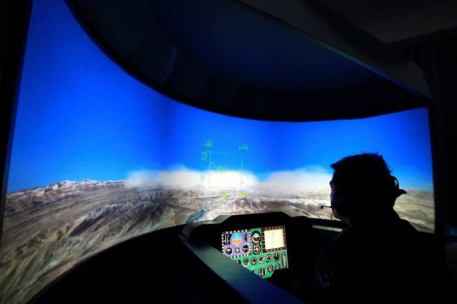
the interface of simulation system In recent years, China has built and converted five large strategic airports near the Sino-Indian border, which are all high-grade airport for large transport aircraft taking off and landing. Nyingchi Airport: located at the Mainling territory’s Brahmaputra valley and only kilometers from the southern Tibet Sino-Indian border area. China started construction in October 2003, a total investment of 780 million yuan, 2,949 meters above sea level. Nyingchi Airport opened at the end of 2005. Shigatse Pingan airport: Shigatse Pingan airport’s location is near the highway of China and Nepal border. From Shigatse Pingan airport, people can easily reach of the Himalayas Mountain area. Airport is 3782m above sea level. Shigatse Pingan airport opened at the October, 2010. Qamdo Bangda Airport: Qamdo Bamda Airport, located in Bamda, Qamdo, is the highest airport in the world, at an elevation of 4,334 metres. It has the longest publicly used runway in the world, at 5,500 m. The airport’s expansion was completed in July 2009. Ngari Gunsa Airport: Ngari Gunsa Airport is a dual-use military and civil airport serving the town of Shiquanhe in Ngari Prefecture, in the southwest of China’s Tibet Autonomous Region and only only 90 kilometers away from the northern section of the disputed territory and India. It started operations on 1 July 2010, becoming the fourth civil airport in Tibet after Lhasa, Nyingchi, and Qamdo airports. Situated at 4,274 m (14,022 ft) above sea level, Gunsa Airport has the best airport of takeoff and landing conditions of the Tibet Autonomous Region. The runway length of 4,500 meters can meet taking-off/landing requirements of Airbus A319, Boeing-737, Boeing-700, IL-76, Y-8 transport aircraft and combat aircraft like Su-27, J-10, H-6 bomber. Almost all Northern Indian area is under the radius of 1,000 km range from Ngari Gunsa Airport. Nagqu Dagring Airport is an airport under construction near Nagqu in the Nagqu Prefecture of Tibet. When completed in 2014 it will be the highest airport in the world at 4,436 m, surpassing Qamdo Bangda Airport (also in Tibet) as the highest. Construction began in 2011 and is scheduled to take three years. It Is expected to be completed in 2014 when the airport annual handling capacity of 2.2 million passengers and 15,000 tons of cargo. China plateau airports’ number have been up to 3/4 of the world. According to the plan, by 2020, the Chinese side of the Sino-Indian border, the airport number will be 20. These airports in accordance with the almost the same interval, extending from the northwest to southeast across most of the area of sino-india border security. Half a century has gone by since a border war between China and India broke out in the eastern Himalayas on October 20, 1962. Memories of that war linger not only at the Indian national policymaking level but also in local discourses in northeast India, given the Indian defeat at the hands of China in 1962. The border issue remains disputed. China plans to deploy its fifth-generation fighter aircraft, the J-20 in this region, once the radar-evading stealth fighter jet gets operational by 2018. Six divisions of China’s Rapid Reaction Forces (RRF) are stationed at Chengdu with 24-hour operational readiness and supported by an airlift capability to transport the troops to the India-China border within 48 hours. |
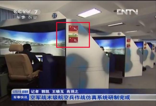 TV screen show that the single unit of simulation is marked with Chinese and Indian national flags
 |
|
|
|
 |
 |
| 实用资讯 | |
|
|
|
|
| 一周点击热帖 | 更多>> |
|
|
|
| 一周回复热帖 |
|
|
|
|
| 历史上的今天:回复热帖 |
| 2012: | 时代大画册 谁在毁灭中华文化?(组图68 | |
| 2012: | 一个骗局——“崇礼惨案”采访经过 | |
| 2011: | 详解中国人民解放军中的朝鲜族部队 | |
| 2011: | ZT 南京大屠杀,高丽棒子也不比倭寇差! | |
| 2010: | 西方瞠目结舌:中国世纪,全球财富聚拢 | |
| 2010: | 世界不敢相信中国真成功了:军火大腕目 | |
| 2009: | Zt极不公正极其腐败的毛泽东时代 | |
| 2009: | 说得太好了!以色列驻华大使回答网友提 | |
| 2008: | 郭泉告中华全国退役军官书 | |
| 2008: | 中国的富人有多富,穷人到底有多穷 | |
